
Dinan, an increasingly popular stopover
Navigating Between Saint-Malo and Dinan: A Mariner’s Guide
The port is managed by the municipality, while the canal falls under regional jurisdiction.
Navigational Challenges and Considerations
The first challenge is navigating the Rance barrage. Passage depends on the water level difference and tidal timing between the sea and the Rance basin. Water levels in the Rance lag behind the Saint-Malo tide by approximately 2 hours and 30 minutes. The Rance barrage lock operates 24/7 when the water level reaches a minimum of 4 meters. The bridge lifts and the seaward lock gate opens on the hour. Note that during the summer season, a prefectural decree may restrict bridge openings. Contact canal 13 or call 02 99 16 37 33 for information. The navigation area in front of the barrage is regulated, with red buoys marking a prohibited zone. White buoys upstream and downstream provide mooring while awaiting lock opening.
Once through the barrage lock, proceed up the Rance to the Châtelier lock. This presents the second challenge. While the Rance estuary is wide, adhering to the buoyage is crucial. From Plouër-sur-Rance, the channel leading to the Châtelier lock narrows. Following the buoyage is essential. Due to silting, it’s advisable to navigate this section on a rising tide, and the Mordreuc/le Châtelier section with a minimum water level of 9.50 meters for vessels with a draft exceeding 1.50 meters. The Châtelier lock operates from 7:00 AM to 9:00 PM, provided the water level in the Rance is at least 8.50 meters.
Between the barrage lock and the Châtelier lock, numerous moorings are available on the eastern bank. The most popular is Montmarin, offering good shelter on a muddy bottom, except in easterly winds. On the western bank, opposite one of France’s most beautiful villages, lies Saint-Suliac.
After passing the Châteaubriand and Saint-Hubert bridges, you’ll find the port of Plouër-sur-Rance (48°31′.5 / 1°1′.5 W) on the western bank. Located 6 nautical miles from the Rance barrage, this port is enclosed by a sill at 6.50 meters above chart datum and topped by a tilting gate that lowers when the level reaches 8.30 meters. Ten berths are reserved for visitors.
Upon exiting the Châtelier lock, the port of Lyvet is situated on the eastern bank, offering a reception pontoon. While there are no shops, two restaurants are available. Between Lyvet and Dinan, the water level remains constant, but the depth restricts access to vessels with a draft exceeding 1.60 meters. On the western bank, the town of Taden has installed quays with mooring rings.
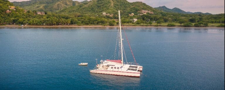
Dinan Port
Dinan port offers various berth types, including alongside and perpendicular moorings with catways. All berths have water and electricity connections. Due to its popularity, especially among British boaters, reserving a berth is recommended (call 06 11 43 51 52). In practice, 80 berths are available. The port manager assures that up to 100 boats can be accommodated during peak periods. Currently, the port is financially stable, and new works are planned, including 8 pontoons for larger vessels and 4 berths reserved for traditional heritage boats. The waiting list for an annual berth currently stands at 80 boats, with a waiting time of 3 to 5 years.
The port is located in the lower town, with numerous restaurants nearby. However, there are no chandleries for boat supplies, except for a bakery.
The upper town sits atop a hill overlooking the Rance at 75 meters. A pleasant route to reach it is the Jerzual, a pedestrianized cobbled street lined with artisan workshops (potters, ceramicists, painters, etc.). However, it’s not ideal for provisioning. To address this, the town provides a bus service to the upper town, and some shops offer delivery services (information available at the harbor master’s office).
A frequently asked question concerns boat licenses: inland or maritime? The Rance is considered inland waterway from the Châtelier lock onwards. In practice, when two seas are connected by a canal (as is the case with the English Channel and the Atlantic), a sailboat can use it without a license. For sea-approved motorboats, the same license (depending on power) is required as for sea navigation. For inland waterway boats, an inland waterway license is required.
If you wish to continue beyond Dinan, you must unstep your mast (3.40 meters bridge clearance at the Dinan port exit and 2.50 meters at Evran). Currently, the crane that previously facilitated this operation in Dinan is no longer operational. This must be done in Saint-Malo or at a shipyard on the Rance before the Châtelier.
A Brief History of Dinan
Dinan’s history dates back to the 11th century, but its transformation began in the 13th century (1283) with its acquisition by the Duke of Brittany (Jean le Roux). The ramparts (2.6 km) were constructed during this period, with four gates providing access to the town (Jerzual, Saint-Malo, Brest, and Guichet). A fifth gate, Saint-Louis, was added in the 17th century (1620). During the War of the Breton Succession, the Du Guesclin brothers (Bertrand and Olivier) defended the town against English troops and Bretons loyal to Jean de Montfort. Control of the town was regained in 1364 by Duke Jean IV, who built the Donjon, known as the Château de la Duchesse Anne. In 1532, Dinan was annexed to the Kingdom of France. The port was very active in the 18th century, with numerous weavers producing sails for ships. These were transported to Saint-Malo via the Rance. However, its importance declined from 1852 onwards. A road viaduct was built, followed by the arrival of the railway in Dinan. The town transformed into a popular destination for the English.
What to See in Dinan
“She has been described by Châteaubriand, painted by Turner, and recounted by Roger Vercel. She remains highly appreciated by artists and creators.”
A must-see is the pedestrianized Jerzual street, connecting the port and the upper town, where you’ll discover numerous half-timbered houses, as well as painters, sculptors, and other artists who welcome visitors to their workshops. The historic town has remained largely unchanged since the early 20th century. Following a fire in 1907 that destroyed some half-timbered houses and a bombing in 1944, its heritage has been restored and maintained.
During your walks, you’ll discover the historic district of Rue de l’Horloge with its 15th-century belfry, standing 45 meters tall and offering exceptional panoramic views of the medieval city after climbing its 158 steps. Explore the 3 km of ramparts with its 14 towers and gates, the 70 historical monuments, the Place des Cordeliers and its convent, the Basilica of Saint-Sauveur housing the cenotaph of the heart of Constable du Guesclin, the Saint-Malo church renowned for its early 20th-century stained glass windows and its English organ with polychrome pipes, and, of course, the Château de la Duchesse Anne. This iconic monument stands as a testament to the princely residences of the late medieval period. Furthermore, a new scenography implemented in 2019 offers insights into daily life and the art of living at the court of Brittany.
Enjoyed this post by Thibault Helle? Subscribe for more insights and updates straight from the source.